
Ferns Irish Background
This article is about the Ferns family name and Irish background.
Ferns Name Origin:
The name Ferns is recorded as originating in both Ireland and Scotland. Hubert's family line is from the Irish source.
A reference states: [4crests.com - Renahan]
"Matheson's 1890 work on births by surnames indicates that in the Birr District, families were interchanging the name Ferns and Renahan. Ferns is an anglicisation of Renahan meaning starry or ferny (like the pointed plant). Both Woulfe & MacLysaght indicate that Ferns derives from Renahan and the Birr Ferns were more than likely to have originally been Renahans, an old Irish name."
The 'Coat of Arms & Family Crests Store' says that regarding the Renahan Coat of Arms / Renahan Family Crest:
"This surname of RENAHAN (also spelt RONAGHAN) is in Irish O'REANNACHAIN. In the 1659 'census' it is given among the principal Irish names in the barony of Tiranny, County Armagh. Today the name is rare, but there are persons of the name in County Cork and in County Monaghan, being long associated with Oriel. The synonym Ferns occurs in Offaly (from the similarity of the word 'raithneach', fern)."
Ferns Irish Origins
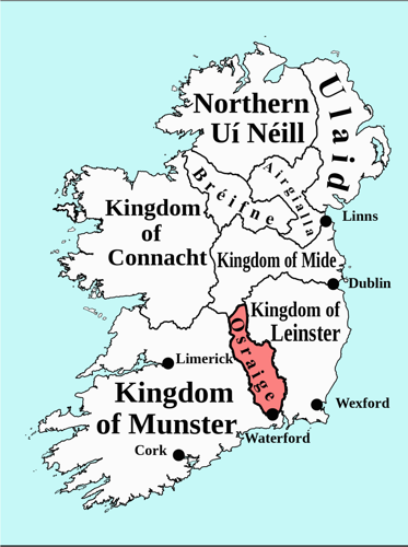
Province of Leinster [Wikipedia - Leinster] [Wikipedia - Dermot]
Historically, in a period following Viking raids and before the Norman invasion, Dermot MacMurrogh (1110-1171) was king of the Province of Leinster. McMurrough upset the High King of Ireland and lost power, but by inviting the Anglo/Norman Richard De Clare (Strongbow) to fight for him, he regained his throne. Strongbow's forces had proceeded from Waterford up to Dublin which they had ransacked. Over the centuries these English gains reduced to an area around Dublin, which was referred to as 'The Pale'. Ireland and Irish forces outside this area were 'beyond The Pale'.
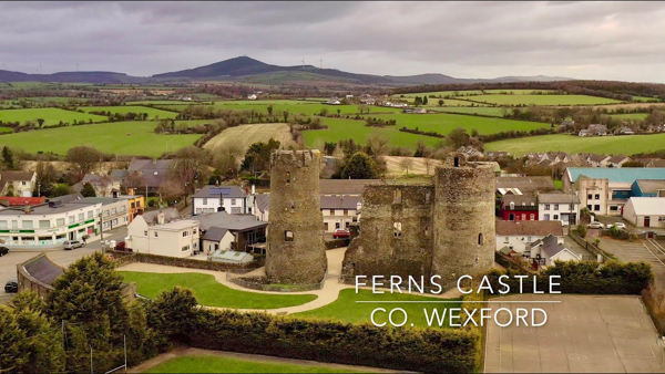
Ferns, County Wexford: [Wikipedia - Ferns]
The northern portion of County Wexford was the territory of the MacMorroughs, who had their chief residence at Ferns. Dermot MacMurrough founded an Augustinian monastery there about 1160. He also captured the English noblewoman, Chelsea of the Willows, bringing her to Ireland to be his wife. On their first anniversary she drugged his wine and set him alight with a log from the fire. Following this, they performed an act of penance by building St. Mary’s Abbey in Ferns.
In Ferns the site of the MacMurrough’s old palace was used in the building of a castle. As the district was actively concerned in the Puritan rebellion of 1641, Ferns Castle was dismantled by parliamentary forces. The ruins of the monastery, abbey and castle remain.
Birr, County Ofally: [Wikipedia - Birr]
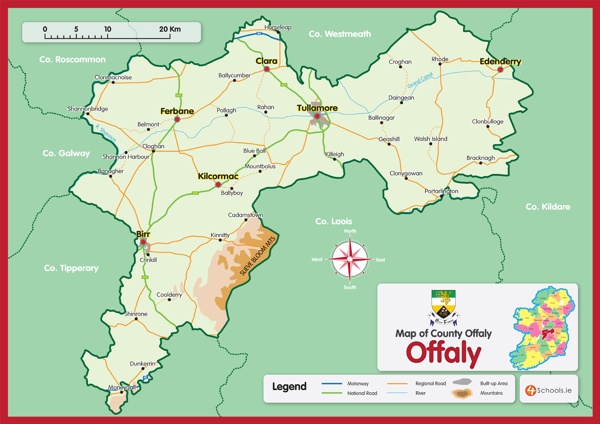
Hubert's father's line is from Birr in County Offaly, a small town located in the mid-west portion of Leinster. Ireland may be thought of as 'dish-shaped' with many cliffs around the outside and bogs in the middle. Birr is in the geographic center of Ireland and is surrounded by bogs.
In 1556 under Mary I the Plantations of King's County (now County Offaly) and Queen's County (now County Laois) were started, displacing the O'Moore and O'Connor clans. This is the earliest attempt at systematic ethnic cleansing by the English in Ireland. The plantations are named after the new Catholic monarchs Mary and her husband Philip II of Spain.
With the forming of the Irish Free State (later to be the Republic of Ireland) in 1922 Queens County reverted back to its original name of County Laois. Kings County changed back to County Offaly in 2001.
So in 1854 when the Ferns family emigrated to Australia by sailing ship the passenger record showed they came from Birr, Kings County, Ireland.
About Offaly
Offaly is a small county located in the midlands of Ireland, the western part of which is dominated by the Shannon River and flat bog lands (Boora Bog), and to the east the Bog of Allen. The Great Shannon Basin was once a lake which, over the years produced the present series of small lakes and large bog areas.
Offaly has seen its share of strife, being invaded up the Shannon River in the 6th century by Vikings, in the 12th century by the Normans and by the English in 1547. The English ’plantation’ settlement which began in 1556 saw a large increase in protestant families. By the 1861 census there were approximately 90% Catholic (mainly native Irish) and 10% Protestant English.
Offaly was badly affected by the Great Famine of 1845-47. The crop which was grown year after year on the densely planted small farms of the peasants was the potato. It had sufficient nutrients and calories for families to live on and formed the staple diet. A new fungal disease appeared in 1845 making the crop blackened and inedible. The crops of 1846 and 1847 were worse affected and it was in this time that the term ’green-mouths’ arose, signifying that the peasants had to eat grass or starve. In 1841 the population of Offaly was 147,000. 22,000 people died between 1845 and 1851 and the population continued to fall through emigration until it reached around 60,000.
Umbilicus Hiberniae
About Birr
The name Birr derives either from the Abbey of Biorra (spring wells), or from ’bior’ which is Irish for the bank of a river. Sir William Petty marked the town as ’Umbilicus Hiberniae’, that is, the 'navel' or centre of Ireland. It has been a military dominated garrison town.
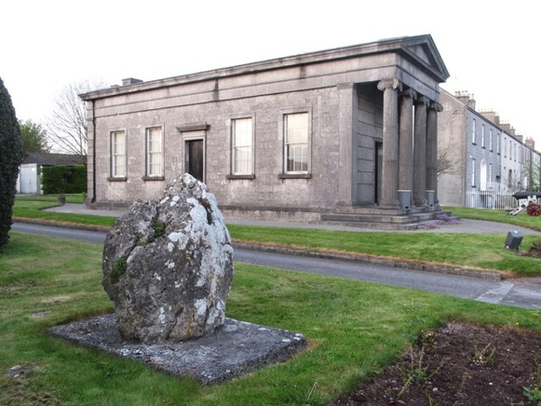
In the center of Birr at Emmet square, formerly Duke Square, is a tall doric pillar. In 1747 it was topped by a statue of the Duke of Cumberland to commemorate his victory over Bonny Prince Charlie at Culloden Moor. However, it was felt that introduced Scottish forces patrolling the Offaly area would have seen red at that sight so the statue was removed and the empty pillar remains standing.
Birr Fun Facts
- Emmet Square commemorates Robert Emmet, an Irish patriot who become a martyr and romantic hero in 1803 when he was tried and hanged for treason by the British.
- Saint Brendan was a 7th century monk who was supposed to have reached America 900 years before Columbus.
- A doric column is fluted, has no base and has a very plain capital (cap).
- The Catholic chapel has two minarets and a 150 foot steeple. It is the cathedral of the Diocese of Birr which incorporates the parishes of Birr and Loughkeen.
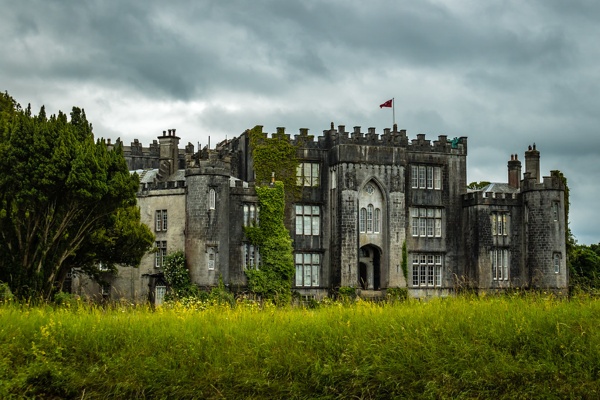
Birr Castle
The castle of Birr was the chief seat of the O’Carrols, chieftains of that sept. In 1620 the castle and lands were seized and assigned to Lawrence Parsons for service to King Charles I. The castle still remains the home of the Parsons family who were later elevated to the peerage as the Earl’s of Rosse. At this time the town of Birr was known as Parsonstown.
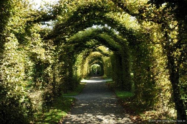
The 2nd Earl was responsible for laying out the castle grounds in nationally recognised splendour. They feature river banks, a lake with a suspension bridge, and 34 foot tall, 200 year old boxthorn hedges which are the tallest in the world. The third and fourth Earls of Rosse carried out significant astronomical work from the castle. In 1845 the third Earl erected a telescope with a 72 inch mirror, which remained the biggest telescope in the world until 1915. The six foot mirror is/was in the London Science Museum and the remains of the massive support walls and wooden tube are at Birr Castle.
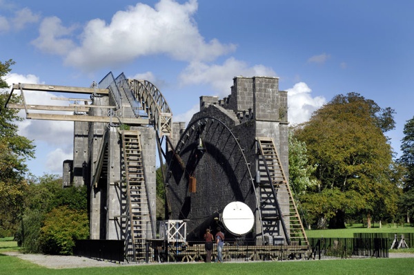
Using this telescope the 3rd Earl discovered the Great Spiral Nebulae. In later years Lord Oxmantown made a 42 inch refractor telescope which stands on the lawn in front of the castle. The 4th Earl’s brother, Sir Charles Parsons, was responsible for the development of the steam turbine. The wife of the present (7th) Earl is the mother of Anthony Armstrong-Jones, the Earl of Snowdon. He married Queen Elizabeth II's sister Princess Margaret in 1960 and they divorced in 1978.
Birr Surroundings
Birr sits midway between the Shannon River and the Slieve Bloom mountains. The flat land of the Great Shannon Basin is prominent for peat bogs and farming of the peat for fuel. The Slieve Bloom mountains are an upthrust of limestone which have been worn over the years by rain and river action. Its highest peak is Ard Erin, which means ’Highest in Ireland’, though it probably isn’t.
Seven miles north of Birr on the Banagher road is Cloghan Castle which was built in 1249. It has 10 foot thick walls, archery holes for 100 warriors, and curly horned Jacob sheep.
The Grand Canal meets the Shannon River a few miles north of the castle. Further north at Shannonbridge the Bord na Mona Blackwater Works operates the Clonmacnoise and West Offaly Railway. The railway surrounds the Blackwater Bog (Boora) and is normally used for transporting peat. The 45 minute circular tour explains the life style of the bog and points out wildlife (the Bord’s rabbits) and bronze-age archeological finds which prove that there was human life here 6000 years ago.
While the above is true for the authors visit in 1994, online research in 2021 indicates that peat harvesting has halted, renewable power systems are being installed (wind, solar), and peat briquettes will be provided until 2024 after which other forms of heating will be required. The Board's workers have been retrained and now actively restore water levels to create new bogland, lakes and water-fowl sanctuaries. Walking and cycling trails are being developed around the new power sources, presumably using high ground above the bogs. [Bord na Mona - Our Vision]
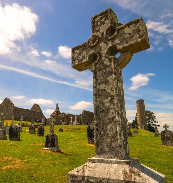
Clonmacnoise, to the north between the Blackwater Bog and the Shannon River, was the headquarters of monk life in Ireland. St Ciaran founded this monastic city in 545 AD and it grew to be a royal city. The last High King of Ireland, Rory O’Connor, was buried here in 1198, and other High King’s, such as those of Connaught and Tara, are scattered around the place.
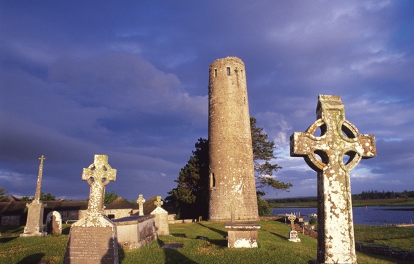
The town was well protected from attack by the river and bogs, however it was still invaded by Vikings and demolished by the English.
It has an informative visitors centre. [Wikipedia - Clonmacnoise]
A few miles east of Birr in the foothills of the Slieve Bloom mountains is Kinnity, a tiny gem of a town. To its south is Leap Castle which had two claims to fame. It was known as the most haunted house in Ireland, and also the place with the smelliest ghost. Apparently, neither claim holds true now as a fire destroyed some of the building, putting an end to the ghostly visitations and air-conditioning has kept down the smells.
A few more miles to the south is Roscrea. There is a genealogical service covering nearby parishes in the Heritage Centre of Roscrea Castle.

East of the Slieve Bloom mountains in County Laois is Port Laoise. Out of town on the Stradbally road is the Rock of Dunamase. A knobbly mound encrusted with layers of fortifications, its history goes back to Ptolemy who called it Dunum, and to Vikings who raided it in 845.
The hill is crowned by a ruined castle of the 12th century King of Leinster, Dermot MacMorrough. Dermot gave Dunamase as a dowry with his daughter to Strongbow, Henry II’s man who had been invited to assist the MacMorroughs. In the shifts of power it was eventually to be blown up by Oliver Cromwell’s troops in 1650. The earth walls 500 yards to its east are still known as ’Cromwell's Lines’. [Wikipedia - Dunamase]
For a video of the Birr Region, see the 'Help' menu item.